
The introduction of mapping applications such as Google Maps (undoubtedly the most popular example of all) and their subsequent widespread use around the world has resulted in an enormous amount of people taking up an interest in an interactive view of the world which previously was very difficult to obtain. There are millions of incredibly interesting sights to experience which, when living at ground level as we do, are rarely seen in the flesh.
As an example, here are some intriguingly shaped communities which take on a new appearance when viewed from the air, along with those same areas pinpointed in embedded maps. Take a look around.
Trails West, Arizona

http: http://maps.google.com/maps?f=q&source=embed&hl=en&q=Tucson, Arizona&sll=34.161143,-112.852592&sspn=0.021058,0.04549&ie=UTF8&cd=1&geocode=FfjB6wEd2CFj-Q&split=0&t=k&ll=32.095373,-110.833082&spn=0.014543,0.025749&z=15&iwloc=A
(Above) To begin, here’s a small mobile home community called Trails West just outside Tuscon, Arizona. The interesting thing about it is the shape as there aren’t many towns or communities with such a distinctly triangular boundary.
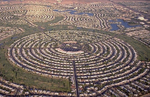
Sun City, Arizona
http: http://maps.google.com/maps?t=k&q=33.597439,-112.272052&ie=UTF8&ll=33.62316,-112.283106&spn=0.014294,0.025749&z=15&source=embed
(Above) Sun City is a planned retirement community in Arizona which, due to it’s design and hundreds of identical houses, offers an incredible view on Google Maps. Dozens of tightly knit roads snake around the area and a even form a couple of huge circular neighborhoods.
Ixtapaluca, Mexico

http: http://maps.google.com/maps?t=h&q=19.318611,-98.882222&ie=UTF8&ll=19.327788,-98.880279&spn=0.008099,0.012875&z=16&source=embed
(Above) The town of Ixtapaluca in Mexico is full of low-income housing identical to the examples you see in the photo above, resulting in rows and rows of cookie-cutter homes which resemble a cartoon-based community. From above, the area is just as uniform and equally as fascinating.
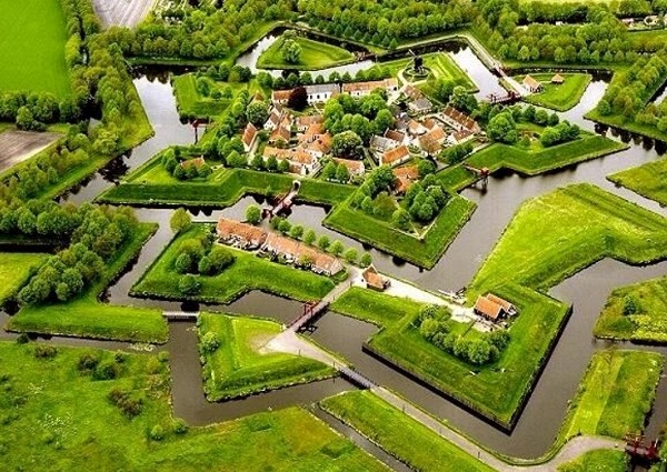
Bourtange, Netherlands
http: http://maps.google.com/maps?t=k&q=53.016667,7.183333&ie=UTF8&ll=53.006456,7.191861&spn=0.005165,0.012875&z=16&iwloc=A&source=embed
(Above) The beautiful star-shaped village of Bourtange was originally built as a fort in the 1500s, the shape chosen due to its highly effective defensive qualities. Today it houses a village and museum and looks incredibly unique, especially when viewed from the air. There are a few other similarly shaped villages around the world but nȯne as defined as this one.
Harborwalk, Texas

http: http://maps.google.com/maps?hl=en&ie=UTF8&q=harborwalk galveston&fb=1&split=1&cid=0,0,10982087079795297591&ei=HyEySrKDDOa6jAf-xIWKCg&t=h&ll=29.288944,-94.96803&spn=0.007486,0.012875&z=16&iwloc=A&source=embed
(Above) Developers in Galveston decided to build a planned community on the wetlands in Galveston and came up with a strange design where houses sit on rings of land which, from above, resemble concentric ripples on the water. At the moment the town is still under development, hence the numerous gaps where homes should stand.
Palm Islands, Dubai

http: http://maps.google.com/maps?t=k&q=25.216667,55.166667&ie=UTF8&ll=25.117621,55.133858&spn=0.062172,0.102997&z=13&iwloc=A&source=embed
(Above) The award for Most Eccentrically Shaped Community has to go to Palm Islands in Dubai, an incredibly ambitious project which will, if ever completed following the financial crisis, consist of 3 separate palm tree shaped islands off the coast. Work on the first island began in 2001 and can be seen on Google Maps. The size and scale of the project is astounding.
Credit seoco.
Related Interesting Articles
12 Most Unfortunate Product Names
Top 5 Most Amazing Wedding Proposals
Top 10 Most Interesting Abandoned Places
Mind Blowing Pencil Drawings
Top 10 Most Amazing Dream Facts
Mind Blowing Photo Manipulations
Top 10 Most Poisonous Animals in the World
11 Coolest Taps You'll Ever See
More Interesting Articles/Videos here
............................................................................................

"I can handle pain till it hurts"
As an example, here are some intriguingly shaped communities which take on a new appearance when viewed from the air, along with those same areas pinpointed in embedded maps. Take a look around.
Trails West, Arizona
http: http://maps.google.com/maps?f=q&source=embed&hl=en&q=Tucson, Arizona&sll=34.161143,-112.852592&sspn=0.021058,0.04549&ie=UTF8&cd=1&geocode=FfjB6wEd2CFj-Q&split=0&t=k&ll=32.095373,-110.833082&spn=0.014543,0.025749&z=15&iwloc=A
(Above) To begin, here’s a small mobile home community called Trails West just outside Tuscon, Arizona. The interesting thing about it is the shape as there aren’t many towns or communities with such a distinctly triangular boundary.
Sun City, Arizona
http: http://maps.google.com/maps?t=k&q=33.597439,-112.272052&ie=UTF8&ll=33.62316,-112.283106&spn=0.014294,0.025749&z=15&source=embed
(Above) Sun City is a planned retirement community in Arizona which, due to it’s design and hundreds of identical houses, offers an incredible view on Google Maps. Dozens of tightly knit roads snake around the area and a even form a couple of huge circular neighborhoods.
Ixtapaluca, Mexico
http: http://maps.google.com/maps?t=h&q=19.318611,-98.882222&ie=UTF8&ll=19.327788,-98.880279&spn=0.008099,0.012875&z=16&source=embed
(Above) The town of Ixtapaluca in Mexico is full of low-income housing identical to the examples you see in the photo above, resulting in rows and rows of cookie-cutter homes which resemble a cartoon-based community. From above, the area is just as uniform and equally as fascinating.
Bourtange, Netherlands
http: http://maps.google.com/maps?t=k&q=53.016667,7.183333&ie=UTF8&ll=53.006456,7.191861&spn=0.005165,0.012875&z=16&iwloc=A&source=embed
(Above) The beautiful star-shaped village of Bourtange was originally built as a fort in the 1500s, the shape chosen due to its highly effective defensive qualities. Today it houses a village and museum and looks incredibly unique, especially when viewed from the air. There are a few other similarly shaped villages around the world but nȯne as defined as this one.
Harborwalk, Texas
http: http://maps.google.com/maps?hl=en&ie=UTF8&q=harborwalk galveston&fb=1&split=1&cid=0,0,10982087079795297591&ei=HyEySrKDDOa6jAf-xIWKCg&t=h&ll=29.288944,-94.96803&spn=0.007486,0.012875&z=16&iwloc=A&source=embed
(Above) Developers in Galveston decided to build a planned community on the wetlands in Galveston and came up with a strange design where houses sit on rings of land which, from above, resemble concentric ripples on the water. At the moment the town is still under development, hence the numerous gaps where homes should stand.
Palm Islands, Dubai
http: http://maps.google.com/maps?t=k&q=25.216667,55.166667&ie=UTF8&ll=25.117621,55.133858&spn=0.062172,0.102997&z=13&iwloc=A&source=embed
(Above) The award for Most Eccentrically Shaped Community has to go to Palm Islands in Dubai, an incredibly ambitious project which will, if ever completed following the financial crisis, consist of 3 separate palm tree shaped islands off the coast. Work on the first island began in 2001 and can be seen on Google Maps. The size and scale of the project is astounding.
Credit seoco.
Related Interesting Articles
12 Most Unfortunate Product Names
Top 5 Most Amazing Wedding Proposals
Top 10 Most Interesting Abandoned Places
Mind Blowing Pencil Drawings
Top 10 Most Amazing Dream Facts
Mind Blowing Photo Manipulations
Top 10 Most Poisonous Animals in the World
11 Coolest Taps You'll Ever See
More Interesting Articles/Videos here
"I can handle pain till it hurts"
